Friday 13 July 2012

Mopping up Glencoe peaks.

Day 1.  Sgor na h-Ulaidh (peak of the treasure) 3261' M149


Drove up through really miserable weather around Glasgow but it got increasingly clearer and brighter the further north I went.  I got to Glen Etive and it was quite pleasant.  

This one is regarded as Glencoe's 'forgotten' mountain as it is hidden from view from that side.  I did try to do it several years ago but was thwarted by an inability to cross a raging torrent of river so retired back to the Clachaig.  Today, I wanted to do it from the Glen Etive side so parked up at the tiny hamlet of Invercharnan, ignored signs warning people to stay off the forest tracks in the area and went along a forestry road to the obvious path to the mountain's base.

Approach to Sgor na h-Ulaidh

Underfoot conditions made for some wet and boggy walking and although it might look easy, there are several convoluted ups and downs on the way to the climb proper.

After some steep donkey-work, the summit is reached.

Sitting proudly on the summit

Summit views

Looking over the Glencoe peaks

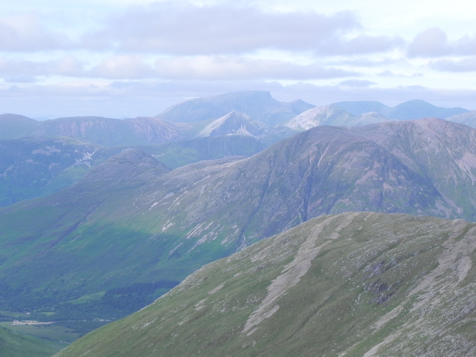
Looking north to Ben Nevis

More summit views

A 'top of the world' feeling

It's a shame this mountain tends to be regarded as one of the least worthy Glencoe peaks because while it might not be a fantastic climb, the views from the summit are amongst the best of any mountain in the area.

So I walked back to my mobile bedroom and assumed the weather would continue like this for a while.  But it didn't.  This day was a reasonably bright spot in a poor summer but you've got to make the most of what's available. 

Views from my 'bedroom' as dusk fell

The glen was incredibly quiet and fortunately for me, there was sufficient wind to keep tomorrow's horrors away.  But it was going to get very bad!

Day 2.  Beinn Fionnlaidh (Finlay's Hill) 3651' M198


Because of the time of year, daylight comes very early and as sleep is difficult in such light, I jumped out of the car to make breakfast.  It didn't take long before being there attracted the attentions of the most evil creature to infest Scotland, Culicoides impunctatus the dreaded Midge  Studies have shown that recent bad winters has increased the numbers of this maddening creature rather than diminishing them.  This is due to a decline in natural predators such as bats and birds.

It became tricky to make breakfast, eat and get ready for the day's climbing while making futile attempts to evade the on-going war of attrition with these pests.  They are so prolific, you start actually breathing them in, which is not pleasant at all.  I was in such a rush to evade the cloud of Culicoides impunctatus, I left the sanctuary of the car (a tent is always much worse as the thin fabric doesn't prevent the carbon dioxide leaving your lungs from attracting the bugs so when you wake, your outer sheet is black with a thick crust of Midges!) leaving a lot of stuff I normally regard as essential behind.


Approach to Beinn Fionnlaidh

A fine bridge!

A rough, stoney track rises steeply above the glen aiming for the summit of the peak.  There are no problems encountered and it wasn't too long before the top was reached.  

Reaching summit

The day was deteriorating and I wanted to grab some pics and get off before the heavens opened.

Some Culicoides impunctatus that have taken residence on my head!

Looking at Loch Awe through the settling mists

Looking across to yesterday's peak

A misty Scotland
A frog

The only living creatures I encountered the entire day were this frog, the evil Midges and a Royal (a twelve-pointed stag from out of my car window on waking that morning).  

So after several trips to the glen, reaching the summit of this one meant I'd climbed all the Glencoe mountains so it was a nice satisfactory feeling to walk back to the car with.  


Thursday 28 June 2012

The 'easiset' Munro?


Day 3.  Carn Aosda (Ancient Hill) 917m/3008' 270


http://connect.garmin.com/activity/193396278

I'm not making any excuses for an easy one.  My legs were tired from the previous few days' climbing but even so, an appearance of the elusive sun might have tempted me to be more adventurous.  As it was, the day was miserable with pouring rain and thick black clouds scudding over.

From my back window

So I decided to go up to Glen Shee and at least familiarise myself with Glen Clunie.  I had read of the height of the road at this point being a huge advantage to an ascent of the many Munros in the area.  With a dowsing being inevitable, I jumped out of the car and reckon on a clear day, you could run up and down this one in about 30 minutes.  It would also be possible to grab all three of the Munros here in about 90 minutes, the central one, The Cairnwell estimated to take as little as 30 minutes to walk this on its own!  

As it was thick low cloud though, I needed to wear waterproof gear and boots and take a map but this wasn't necessary even on a day like this.  There's a big ugly bulldozed track right the way to the summit so I won't write too much about this mountain as there's nothing worth going over.


 Summit, Carn Aosda


A sometimes typical Scottish day


The three Munros of Beinn a' Ghlo.


Day 2.  Bheinn a' Ghlo.  Carn Liath (Grey Hill) 975m/3127', 175, Braigh Coire Chruinn-bhalgain (Height of the Corrie of Round Blisters) 1070m/3432', 63, Carn nan Gabhar (hill of the Goats) 1121m/3596', 29


http://connect.garmin.com/activity/193396314

Parked up at the small lay-by at Loch Moraig and set off for the trio of the day.  Four boisterous University lads parked next to me and were in high spirits for the efforts to come.

The day was gloomy and grey but remained dry until I got back to the car!

This is a mysterious mountain of numerous, remote peaks and many corries.  It is regarded as the finest in the area competing only with Lochnagar for the appreciations of mountain lovers.

The first peak, Carn Liath is easly identified by a huge white scar near the summit ridge.  The climb begins after some boggy ground is navigated and height is gained fairly quickly.  I was familiar with this terrain as I'd climbed Carn Liath once before when the kids were young.  I'd promised them we'd climb Scheihallion that afternoon so that morning, I came out with the intention of doing the entire Beinn a' Ghlo round but when I saw the distances involved from its summit and knew the efforts still to come in the afternoon, I touched the trig point and ran straight off!

The views were restricted at the summit cairn but it started to improve

A Misty summit

With the mists down, navigation became more difficult.  It was also cold now and great care had to be taken to avoid getting lost.

Careful compass work pointed the way to the second peak, Braigh Coire Chruinn-bhalgain which doesn't refer to blisters on the feet but it's a descriptive words for small white-ish stones which the mountain contains a profusion of.  A steep descent down to a col is immediately followed by a climb up the broad ridge to the summit of this middle peak.

Summit Braigh Coire Chruinn-bhalgain

Looking to day's last peak

From this top, a short ridge walk leads to another descent to the next col and a steepening climb is made to the col between the summit and Airgiod Bheinn, an outlier it seemed necessary to climb.  At the foot of this outlier though, there were several tracks leading down to Glen Girnaig and to me, these seemed preferable to take rather than the climb and severe descent off Airgiod Bheinn.  

Summit, Carn nan Gabhar

Third top

This is a broad, stony ridge with three possible summit points, the highest being the final one at the north-east end about 200 yards beyond the biggest trig point which may be taken to be the top.  The one thing I wanted to see but was denied me was the mists to the east blocking out a view of the imaginatively named Loch Loch! 

I noticed the four students coming up past a trio of descending walkers way down the col below the obvious track up to Airgiod so I suspected this was worth looking at.  I didn't want to go back and reverse the outward route, re-tracing the steps I'd taken, so was apprehensive the descenders would go that way.  But they clearly hadn't and must also have seen the paths off the mountains I'd seen but which aren't mentioned in any book.  It is well worth taking if only to avoid the brutal descent off Airgiod Bhienn and gets you a quicker descent down to Glen Girnaig.

The lower slopes were boggy and cloying, heather and brambles scraping and scratching at legs and boots and was the most dreary part of the whole day.  It's a long, wearying treck back to the road and the sanctuary of your car.  But I got there just in time as I'd managed to change out of my wet clothes seconds before the first big fat raindrops began to explode on the windscreen!


Another Munro raid.


Day 1.  Carn a' Chlamain (The hill of the Kite) 963m/3089'.  188


http://connect.garmin.com/activity/193396352

The drive up to Blair Atholl saved me the long, interminable journey around Loch Lomond.  From there, a short drive up to the old Bridge of Tilt brings you to the car park right at the entrance point of the private road that runs through Glen Tilt.

Bike loaded and ready to go


My (t)rusty bike took me along the really lovely river Tilt which was running fairly high with its peaty brown cascade dropping down through many rock pools.

Bridge over River Tilt

It was a good day and the hills looked very enticing.  My goal for today was on my left (north) while tomorrow's targets were on my right (south)

Glen Tilt with Carn a' Chlamain ahead

There are some really nice cottages en-route and after about five miles, the cottage of Marble Lodge is reached.  From there, I hid my bike in some undergrowth as this would be where I would return back to the road. 

Bike hidden in trees

After stowing the bike, it's a pleasant walk of about two miles on the flattish road (more of a dirt track) to Forest Lodge.  From a point adjacent to the last building of the property, a well-constructed Stalker's Path rises high up onto a broad crest of a ridge.  Once there, the unmistakeable shape of Carn a' Chlamain beckons ahead. 

A very well constructed track rises to just below the summit.

While these hills may not be as scenic or as attractive as their western counterparts, there is no shortage of them!  The profusion of hills all around goes on and on into wilder country.  One noticeable thing is the number of bothies.  Some of these mountains are a long, long way from any road or habitation so the bothy network could be used to good effect to enable walkers and climbers to get within striking distance of some of the more remote outliers.  

Approaching summit

Looking at tomorrow's hills from summit

So from there it was a very easy descent back to the Marble Lodge as it is gently graded with no steep drops or rocky ground to navigate.  I was thinking it may be better to do it this way round, clockwise, as opposed to the anti-clockwise way I'd gone about it.  The only other people I'd seen that day were a Glaswegian couple descending the way I'd gone up but they told me they'd have preferred my way!  The other man's grass, and all that.  


Tuesday 19 June 2012

Monday June 18th.  Foel-Fras from Abergwyngregyn


This has the benefit, for me, of being able to drive there, climb it and drive back in the same day!  Okay, it's not in Scotland but it does breach the required height, it is a separate mountain and was the final Welsh 'Munro' I needed to climb.

http://connect.garmin.com/activity/190553089

I took a guide downloaded from a Snowdonia site with me and followed the route but quickly found I'd gone a bit wrong.  Either the expected sign pointing the way up Drum from the Roman Road path was missing, or I'd missed it.  Either way, it was very clear so no problem, dead-reckon the way up and aim for that ridge.  It was a bit wet underfoot but that's to be expected.  I also like the wildlife you get in this part of the world that you don't see on the flanks of Scottish mountains; horses!  Lots of them too.

Ridge between Drum and Foel-Fras


Reach a welcome ridge in Scotland and you still have an enormous amount of work to do.  Reach this ridge, and it's a pleasant grassy stroll to the summit!

Track to Foel-Gras

Excellent spot for some dinner


Snowdonia

Summit, Foel-Fras

It was a pleasant day and the views from this summit were excellent.  It was tempting to stay here all day and enjoy the scenery but unless you bring a tent or bivi, you've got to leave sometime.  Rather than follow the usual path, I decided to just head straight down to a point above the Aber falls and this proved to be very easy, very quick and very direct.  

Aber falls


Sunday 17 June 2012

13th June.  A mixed week; trip postponed but three Munros climbed.


I went to Scotland hoping to join a trip to Knoydart to climb Luinne Bheinn, Ladhar Bheinn and Meall Buidhe.  This was to be done from Inverie sailing from Mallaig and my route up there took me past two jewels I wanted to climb, Sgurr Thuilm and Sgurr nan Coireachan.  It was a very early start for the 330-odd mile drive and so the legs were stiff from the +5 hour confinement in the driver's seat.

Sgurr Thuilm (Peak of the rounded Hillock) 963m/3159' 189, Sgurr nan Coireachan (Peak of the Corries) 956m/3136', 202


I found the appropriate car park in Glenfinnan, readied the bike, mainly to reduce the long walk out as much as anything, and was underway pretty quickly.

The route goes under the famous viaduct shown in the Harry Potter films and it is a good, easily bikeable track to the Corryhully bothy.  The track gets rougher beyond there but although it's still cycleable, I left the bike in a small forest adjacent to the bothy. 


After kitting up, it was time to ascend the track northwards towards the start of the climb on a fine stalker's path although a decision had to be made.  Was it to be Sgurr nan Coireachan first or second?  The suggestion is that Coireachan was to be first as there is a sign (on a Scottish mountain!) pointing out that route.  My preference though, as tempting as this was, was to go anti-clockwise and climb Thuilm first so I pushed on until coming across another sign pointing out the start of the stalker's track to do it this way round. 

Although described as steep and unrelenting, the path is well-graded and being lucky enough to find the surface bone dry, this was made considerably easier than it normally must be.  After the 6.5 mile journey was also aided by doing about 2.5 miles by bike, the summit was eventually reached.  And it was a very attractive summit indeed!
High above Loch Arkaig


Although tempted to savour the fabulous views for a lot longer, the worst, most evil creature to blight these wondrous places were out in great numbers.  The hideous midge saw me as a walking feast and dined luxuriously on my blood! 
A midge's meal


I had to tear myself away from the warm, comfortable lofty position in order to march across the intervening distance between the two summits to Coireachan but the views northwards were superb.

A distant Sgurr na Ciche in a remote wilderness

It was a bumpy walk from one summit to the other and I met the only other person I saw that day as he came the opposite way to me.  We exchanged notes as I'd done what he was about to do and vice versa so I warned him of the peril on top of where he was aimed for and he warned me of the many ups and downs between me and my goal. 

The summit of Sgurr nan Coireachan

The ridge back to Sgurr Thuilm

The evil creatures weren't out in force here so although it was tempting to savour superb views over the wilderness to the north as well as the outline of Rhum and the Cuillin on Skye, the sky above me seemed to threaten thunder so I decided to whizz down as fast as I could

The path is well constructed and leaves you in no doubt as to which way to go.  Since I've never been what you might call 'proficient' as far as navigating goes, this blessing makes the route very easy to follow and despite the very steep ground falling away back to Glenn Finnan, fast progress can be made.  And of course, faster progress was made once I got down into the glenn as my trusty bike was there, untouched so I jumped aboard and whizzed out from the glenn back to my car.

Here's a summary of the actual route http://connect.garmin.com/activity/189512284

I then whizzed up to a caravan I'd booked for two nights prior to my trip to Knoydart.  I spent Thursday resting before the huge walks and climbs to come over the weekend.  The problem arose late Thursday night.  The winds were very, very strong.  Gusts of such ferocity have a habit of blowing themselves out but this one didn't.  If anything, it got stronger and stronger making the caravan an uncomfortable place to be.  Sleep was difficult due to the noise and the frequent bumps and bangs caused by structural damage around me.  I could also imagine the roughness of the boat's crossing to Knoydart and not having a strong stomach at sea, I began to wonder about the likelyhood of a cancellation. 

Friday morning came with steel-grey skies and the howling winds hadn't let up for even a second.  I had fears about the car journey to Mallaig for the sailing so had some trepidation about what was to come.  And that was no sailing!  This had me half cursing and half blessing the postponement of the Knoydart trip but nothing was to be gained by whingeing so there was only one thing to do; another Munro!

I whizzed down to Glenfinnan where I'd climbed from two nights' previously and a few miles east of there, found the spot from where to begin the assault on Gulvain.  Gulvain looked marvelous two days ago and is also a mountain that can be climbed with the assistance of a bike. 

Gulvain (either gaorr, filth or gaoir, noise) 987m/3757', 156

The vehicle in front of me belonged to the Scotsman I'd met between Thuilm and Coireachan two days ago and we had a long natter about today's climb.  The weather had changed and become more 'Scottish' if you will.  The bone-dry ground was soaking up the liberal quantities of wetness falling out of the sky.  It wasn't going to be a pleasant trek but since I was here, it was going to be done!

The track up to the base of the climb is nowhere near as smooth or as easy as the one to Corryhully bothy but it at least reduced the walking distance in and out so had to be tackled.  The track is rough and bouldery but reasonably flat.  Again, I stowed the bike at the foot of the slope and set off up the zig-zagging stalker's track leading inexorably to the summit.  Sadly, I can't describe the views or the surrounding peaks from this summit as despite being June, it was bitterly cold in the very strong winds at the top and it was very misty.  My hands were numb and sore so it was just one quick snap before turning round and rushing down.

Summit, Gulvain

Now I realise that could have been taken anywhere but here's a summary of my route taken from my Garmin Forerunner watch; http://connect.garmin.com/activity/189717529

Saturday 2 June 2012

Saturday 2nd June 2012.  Dun Fell.  A bike ride up Britain's highest paved road.


That was a BRUTAL climb, on Britain's highest paved road, made much worse by a very strong wind against us the entire way up.  And it was very cold.  I did it with our Liam and we were in heavy cloud from about 700 feet so were denied a view and denied a clue as to where we had to ride to.  When we got to the summit, it was so cloudy, it was possible to stand there and not see the huge golf-ball that sits on the top!

I had the nous to take some liner gloves and put these over my cycling mitts so was prevented the bitter-fingered pain of the cold intensified by the wind-chill on the incredibly fast descent.  Liam didn't have the foresight so suffered accordingly on the way down.

There's no doubt we'll go back to do it in more favourable conditions but coming down fast on a bike gave us an experience you never get walking or running down a mountain.  We descended at speeds of up to 50 mph and so we dropped below the clouds in the blink of an eye rather than getting used to it incrementally.  A really wonderful part of the world to see by bike.

http://connect.garmin.com/activity/184675096